Click Here to view Map Legend
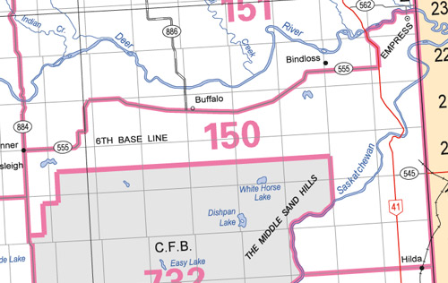
Jenner Wildlife Management Unit (150)
Commencing at the junction of secondary road 884 and secondary road 555 near Jenner; thence easterly along secondary road 555 to highway 41; thence northerly along highway 41 to the Red Deer River; thence easterly along the right bank of the Red Deer River to the Alberta-Saskatchewan boundary; thence southerly along the Alberta-Saskatchewan boundary to township road 18‑0, also known as Hilda road; thence westerly along township road 18‑0 and continuing westerly for approximately 2.5 miles along the undeveloped road allowance 18‑0 to the eastern boundary of the Suffield Military Reserve; thence northerly, westerly and southwesterly along the eastern, northern and western boundaries of the Suffield Military reserve to a point where the boundary meets secondary road 884 approximately 13 miles south of Jenner; thence northerly along secondary road 884 to the point of commencement.