Click Here to view Map Legend
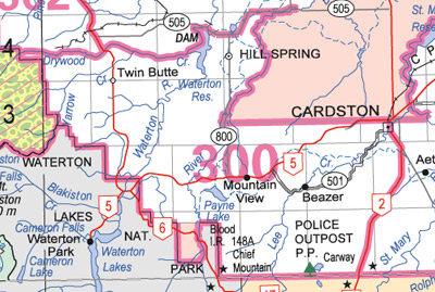
Mountain View Wildlife Management Unit (300)
Commencing where highway 2 crosses the southern boundary of the Blood Indian Reserve #148 near Cardston; thence southerly along highway 2 to the Alberta‑Montana boundary; thence westerly along the Alberta‑Montana boundary to the southeast corner of Waterton Lakes National Park; thence northerly and westerly along the eastern and northern boundaries of Waterton Lakes National Park to the southwest corner of section 15‑3‑30‑W4; thence north to the northeast corner of section 16‑3‑30‑W4; thence west to the northeast corner of section 17‑3‑30‑W4; thence north to the northeast corner of section 32‑3‑30‑W4; thence west to the northeast corner of section 36‑3‑1‑W5; thence north to the northeast corner of section 12‑4‑1‑W5; thence west to the northeast corner of section 10‑4‑1‑W5; thence north to the right bank of Drywood Creek at the northwest quarter of section 14‑4‑1‑W5; thence downstream along the right bank of Drywood Creek to the Waterton Reservoir; thence northerly and easterly along the western and northern shores of Waterton Reservoir to secondary road 505; thence easterly and northerly along secondary road 505 to the western boundary of the Blood Indian Reserve; thence southerly and easterly along the western and southern boundaries of the Blood Indian Reserve to the point of commencement.