 |
Click Here to view Map Legend
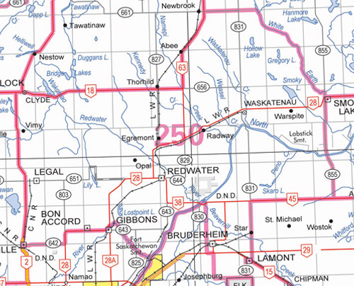
Redwater Wildlife Management Unit (250)
Commencing at the junction of highways 2 and 18 near Clyde; thence easterly along highway 18 to highway 63; thence northerly along highway 63 to secondary road 661; thence easterly along secondary road 661 to secondary road 831; thence continuing easterly along the northern boundary of township 61 to the west bank of the unnamed lake in the northeast quarter of section 35, township 61, range 19, west of the fourth meridian; thence southerly along the west bank of that unnamed lake to the right bank of White Earth Creek; thence downstream along the right bank of the White Earth Creek to secondary road 855; thence southerly along secondary road 855 to highway 45; thence westerly along highway 45 to secondary road 831; thence southerly along secondary road 831 to the northern boundary of Elk Island National Park; thence westerly along the northern boundary of Elk Island National Park and the northern boundary of township 54 (township road 550 in the Strathcona County rural addressing system) to range road 204; thence northerly on range road 204 to highway 15; then westerly along highway 15 to range road 205; thence northerly along range road 205 to the right bank of the North Saskatchewan River; thence upstream along the right bank of the North Saskatchewan River to a point directly opposite the mouth of the Sturgeon River; thence directly to the right bank of the Sturgeon River; thence upstream along the right bank of the Sturgeon River to highway 28A; thence northerly along highway 28A to highway 28; thence westerly and southerly along highway 28 to secondary road 642; thence westerly along secondary road 642 to highway 2; thence northerly along highway 2 to the point of commencement.